Shepparton sits on the floodplain of the Goulburn River, where the underlying Quaternary alluvial deposits consist of clay, silt, and sand layers with variable consistency. The region's irrigation history has raised the water table significantly, creating conditions that can trigger shallow translational slides on even moderate slopes. Our team approaches landslide assessment in Shepparton by first reviewing existing borehole logs and then designing a site-specific exploration program. We integrate shear strength testing from undisturbed samples with groundwater monitoring to model failure surfaces under both drained and undrained conditions. For projects near the Goulburn River or irrigation channels, where seepage forces are critical, we often combine this assessment with a permeability field test to measure hydraulic conductivity in situ. Understanding the spatial variability of the soil profile is essential to predicting the depth and geometry of potential sliding planes.
High pore pressures from irrigation in Shepparton's alluvial clays reduce effective stress and can drop slope safety factors below 1.3.
Method and coverage
- Detailed topographic survey to identify tension cracks, scarps, and bulging toe zones
- Continuous core drilling with SPT testing at 1.5 m intervals to log soil types and consistency
- Installation of standpipe piezometers to monitor pore pressure fluctuations over at least one wet season
Regional considerations
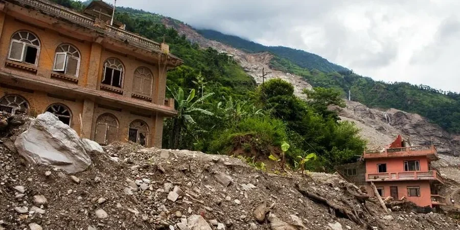
The alluvial clays of the Shepparton Formation are known for their high plasticity index, often exceeding 40 %, which makes them prone to significant strength loss upon saturation. When combined with the shallow water table — typically between 1.5 m and 3 m in the Goulburn Valley — the risk of progressive failure increases substantially. Our field data from the region show that swelling and shrinkage cycles in the upper 2 m of soil can create desiccation cracks that act as preferential flow paths for infiltration. These cracks reduce the overall stability of the slope, especially along the edges of drainage channels and road cuttings. Without a proper landslide assessment, the long-term creep movement can go unnoticed until it damages foundations or pavements.
Standards that apply
AS 1726:2017 Geotechnical site investigations, AS 4678:2002 Earth-retaining structures, AS/NZS 1170.2:2021 Structural design actions – wind actions, FHWA-NHI-05-084 Slope stability reference manual
Complementary services
Slope Stability Analysis and Modeling
We perform limit equilibrium and finite element analyses using software validated against field data from Shepparton's alluvial soils. Output includes factor of safety contours, critical slip surface geometry, and parametric sensitivity to water table rise. We also provide stabilization recommendations such as drainage blankets, soil nails, or retaining walls where needed.
Piezometer Installation and Monitoring
Standpipe and vibrating-wire piezometers are installed at strategic depths to record pore pressure response to rainfall and irrigation cycles. Data is logged weekly during the wet season and monthly during dry periods. This long-term monitoring is essential for validating the assumptions used in the landslide assessment and for adjusting the factor of safety calculations.
Typical parameters
Top questions
What is the typical cost range for a landslide assessment in Shepparton?
The cost for a professional landslide assessment in Shepparton generally falls between AU$1.590 and AU$6.630, depending on the site size, number of boreholes, laboratory testing requirements, and the complexity of the slope geometry. We recommend requesting a detailed scope of works to get an accurate quote for your specific project.
How long does a landslide assessment take from start to finish?
A standard landslide assessment for a single slope in Shepparton typically takes 4 to 8 weeks. This includes site mobilization, drilling and sampling (1–2 days), laboratory testing (2–3 weeks), data analysis and modeling (1–2 weeks), and report preparation (1 week). If long-term piezometer monitoring is included, the timeline extends to cover at least one wet season.
What is the difference between a landslide assessment and a slope stability analysis?
A landslide assessment is a broader geotechnical investigation that includes site reconnaissance, subsurface exploration, groundwater monitoring, and laboratory testing to identify failure mechanisms. Slope stability analysis is a specific computational step within that assessment where the factor of safety is calculated using methods like Bishop or Morgenstern-Price. The assessment provides the input parameters for the analysis.
Do I need a landslide assessment for a small residential block in Shepparton?
Yes, especially if your property is near the Goulburn River, an irrigation channel, or has a slope steeper than 5 %. Local council regulations may require a geotechnical report for any development on sloping land. Even a shallow slide can damage retaining walls, driveways, or building foundations, so a targeted assessment is a cost-effective way to avoid future repairs.
What laboratory tests are included in a standard landslide assessment?
The laboratory program typically includes Atterberg limits (plasticity index), triaxial shear testing (CU or CD), direct shear on undisturbed samples, and moisture content profiles. For Shepparton's alluvial clays, we also perform consolidation tests to measure pre-consolidation pressure and swelling potential. All tests follow AS 1289 standards.